
Topografische Karte Ellettsville
Interaktive Karte
Klicken Sie auf die Karte, um die Höhe anzuzeigen.
Über diese Karte
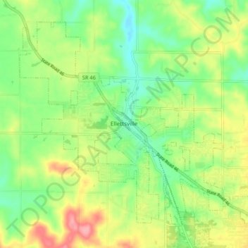
Name: Topografische Karte Ellettsville, Höhe, Relief.
Ort: Ellettsville, Monroe County, Indiana, United States (39.20808 -86.65918 39.25968 -86.57832)
Durchschnittliche Höhe: 235 m
Minimale Höhe: 193 m
Maximale Höhe: 296 m
Andere topografische Karten
Klicken Sie auf eine Karte, um ihre Topografie, ihre Höhe und ihr Relief anzuzeigen.
Bloomington
United States > Indiana > Monroe County
Bloomington, Monroe County, Indiana, United States
Durchschnittliche Höhe: 241 m
Clear Creek
United States > Indiana > Monroe County > Clear Creek
Clear Creek, Monroe County, Indiana, United States
Durchschnittliche Höhe: 218 m
University Lake Dam
United States > Indiana > Monroe County > Bloomington
University Lake Dam, Bloomington, Monroe County, Indiana, 47408, United States
Durchschnittliche Höhe: 236 m
Upper Cascades Park
United States > Indiana > Monroe County > Bloomington
Upper Cascades Park, Bloomington, Monroe County, Indiana, United States
Durchschnittliche Höhe: 217 m
Broadview
United States > Indiana > Monroe County > Bloomington
Broadview, Bloomington, Monroe County, Indiana, 47402, United States
Durchschnittliche Höhe: 231 m