
Topografische Karte Arkhyz
Interaktive Karte
Klicken Sie auf die Karte, um die Höhe anzuzeigen.
Über diese Karte
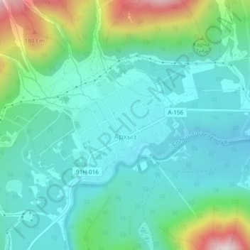
Name: Topografische Karte Arkhyz, Höhe, Relief.
Durchschnittliche Höhe: 1.547 m
Minimale Höhe: 1.427 m
Maximale Höhe: 1.937 m
Arkhyz (also Nizhny Arkhyz Russian: Архыз; Karachay-Balkar: Ырхыз, Irxız; "mudflows") is a village in the valley of the Bolshoy Zelenchuk River, in the Republic of Karachay–Cherkessia, Greater Caucasus, Russia, about 70 km inland from the Black Sea shore. The modern village was founded in 1923 near the confluence of the Arkhyz and Pshish rivers. It is located in a mountainous region in the vicinity of the eponymous aul sitting at an altitude of 1,450 meters. The elevation of the surrounding mountains is more than 3,000 meters above the sea. The population is 505 (2010 Census).
Andere topografische Karten
Klicken Sie auf eine Karte, um ihre Topografie, ihre Höhe und ihr Relief anzuzeigen.
Архыз
Russia > Karachay-Cherkessia > Zelenchuksky District
Архыз, Архызское сельское поселение, Zelenchuksky District, Karachay-Cherkessia, North Caucasian Federal District, Russia
Durchschnittliche Höhe: 2.345 m