
Topografische Karte Rockton Township
Interaktive Karte
Klicken Sie auf die Karte, um die Höhe anzuzeigen.
Über diese Karte
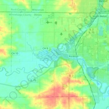
Name: Topografische Karte Rockton Township, Höhe, Relief.
Durchschnittliche Höhe: 235 m
Minimale Höhe: 216 m
Maximale Höhe: 280 m
Andere topografische Karten
Klicken Sie auf eine Karte, um ihre Topografie, ihre Höhe und ihr Relief anzuzeigen.
Rockford
United States > Illinois > Winnebago County
Rockford, Rockford Township, Winnebago County, Illinois, United States
Durchschnittliche Höhe: 242 m
Shirland
United States > Illinois > Winnebago County
Shirland, Shirland Township, Winnebago County, Illinois, United States
Durchschnittliche Höhe: 233 m
New Milford
United States > Illinois > Winnebago County > New Milford
New Milford, Winnebago County, Illinois, United States
Durchschnittliche Höhe: 238 m