Topografische Karte Ghatti
Interaktive Karte
Klicken Sie auf die Karte, um die Höhe anzuzeigen.
Über diese Karte
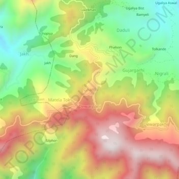
Name: Topografische Karte Ghatti, Höhe, Relief.
Ort: Ghatti, Bhikiasain, Almora, Uttarakhand, 263646, India (29.58678 79.24361 29.62678 79.28361)
Durchschnittliche Höhe: 1.463 m
Minimale Höhe: 1.003 m
Maximale Höhe: 1.957 m
Andere topografische Karten
Klicken Sie auf eine Karte, um ihre Topografie, ihre Höhe und ihr Relief anzuzeigen.
Saboli Magchyori
India > Uttarakhand > Bhikiasain > Hikyasen
Saboli Magchyori, Hikyasen, Bhikiasain, Almora District, Uttarakhand, 263667, India
Durchschnittliche Höhe: 996 m
Katuli
India > Uttarakhand > Bhikiasain
Katuli, Bhikiasain, Almora District, Uttarakhand, 263667, India
Durchschnittliche Höhe: 1.028 m
Manila
India > Uttarakhand > Bhikiasain
Manila, Bhikiasain, Almora, Uttarakhand, 263667, India
Durchschnittliche Höhe: 1.501 m
Jainal
India > Uttarakhand > Bhikiasain
Jainal, Bhikiasain, Almora, Uttarakhand, 263667, India
Durchschnittliche Höhe: 1.025 m
Basot
India > Uttarakhand > Bhikiasain > Basot
Basot, Bhikiasain, Almora, Uttarakhand, 263680, India
Durchschnittliche Höhe: 1.105 m
Bhikia Sain
India > Uttarakhand > Bhikiasain
Bhikia Sain, Bhikiasain, Almora District, Uttarakhand, 263667, India
Durchschnittliche Höhe: 971 m