
Topografische Karte Tizayuca
Interaktive Karte
Klicken Sie auf die Karte, um die Höhe anzuzeigen.
Über diese Karte
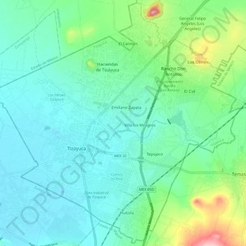
Name: Topografische Karte Tizayuca, Höhe, Relief.
Ort: Tizayuca, Hidalgo, Mexico (19.79857 -99.02058 19.90672 -98.90298)
Durchschnittliche Höhe: 2.306 m
Minimale Höhe: 2.261 m
Maximale Höhe: 2.469 m
Andere topografische Karten
Klicken Sie auf eine Karte, um ihre Topografie, ihre Höhe und ihr Relief anzuzeigen.
Santiago Tulantepec
Mexico > Hidalgo > Santiago Tulantepec de Lugo Guerrero
Durchschnittliche Höhe: 2.260 m
Sangre de Cristo
Mexico > Hidalgo > Santiago Tulantepec de Lugo Guerrero
Durchschnittliche Höhe: 2.413 m
Barrio los Violines
Mexico > Hidalgo > Francisco I. Madero > Tepatepec
Durchschnittliche Höhe: 1.989 m
Col. Loma Bonita
Mexico > Hidalgo > Atotonilco de Tula > Atotonilco de Tula > Col. Loma Bonita
Durchschnittliche Höhe: 2.164 m
Pachuca
Mexico > Hidalgo > Pachuca de Soto
Pachuca has a semi-arid climate (Köppen climate classification BSk). The climate is cool with high rainfall and occasional hail during the summer months and dry conditions during the winter. The coldest month is January, with an average high of 20 °C (68 °F) and an average low of 3 °C (37 °F). Winter…
Durchschnittliche Höhe: 2.459 m