
Topografische Karte Haley
Interaktive Karte
Klicken Sie auf die Karte, um die Höhe anzuzeigen.
Über diese Karte
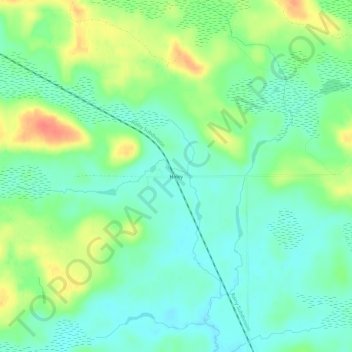
Name: Topografische Karte Haley, Höhe, Relief.
Ort: Haley, Saint Louis County, Minnesota, United States (47.90103 -92.75267 47.94103 -92.71267)
Durchschnittliche Höhe: 417 m
Minimale Höhe: 399 m
Maximale Höhe: 450 m
Andere topografische Karten
Klicken Sie auf eine Karte, um ihre Topografie, ihre Höhe und ihr Relief anzuzeigen.
Babbitt
United States > Minnesota > Saint Louis County
Babbitt, Saint Louis County, Minnesota, United States
Durchschnittliche Höhe: 484 m
Ash Lake
United States > Minnesota > Saint Louis County
Ash Lake, Saint Louis County, Minnesota, United States
Durchschnittliche Höhe: 413 m
Little Swan
United States > Minnesota > Saint Louis County > Hibbing
Little Swan, Hibbing, Saint Louis County, Minnesota, United States
Durchschnittliche Höhe: 395 m
Four Corners
United States > Minnesota > Saint Louis County
Four Corners, Saint Louis County, Minnesota, United States
Durchschnittliche Höhe: 438 m
Dark River
United States > Minnesota > Saint Louis County > Mountain Iron
Dark River, Mountain Iron, Saint Louis County, Minnesota, United States
Durchschnittliche Höhe: 458 m
Buckshot Lake
United States > Minnesota > Saint Louis County
Buckshot Lake, Saint Louis County, Minnesota, United States
Durchschnittliche Höhe: 463 m
Duluth
United States > Minnesota > Saint Louis County
Duluth, Saint Louis County, Minnesota, United States
Durchschnittliche Höhe: 286 m
Evelyn Lake
United States > Minnesota > Saint Louis County
Evelyn Lake, Saint Louis County, Minnesota, United States
Durchschnittliche Höhe: 471 m
Mug Lake
United States > Minnesota > Saint Louis County
Mug Lake, Saint Louis County, Minnesota, United States
Durchschnittliche Höhe: 375 m
Crane Lake
United States > Minnesota > Saint Louis County
Crane Lake, Saint Louis County, Minnesota, 55725, United States
Durchschnittliche Höhe: 357 m
Kelly Lake
United States > Minnesota > Saint Louis County > Hibbing
Kelly Lake, Hibbing, Saint Louis County, Minnesota, United States
Durchschnittliche Höhe: 467 m
Chisholm
United States > Minnesota > Saint Louis County
Chisholm, Saint Louis County, Minnesota, United States
Durchschnittliche Höhe: 463 m