
Topografische Karte Jagdevpur
Interaktive Karte
Klicken Sie auf die Karte, um die Höhe anzuzeigen.
Jagdevpur
Located at 17°46′05″N 78°48′29″E / 17.768°N 78.808°E / 17.768; 78.808, Jagadevpur has an average elevation of 568 metres (1,864 ft). It is the fourth-largest mandal of the Siddipet district. Jagadevpur is 70 km north of Hyderabad and 30 km each from Bhongir and the famous Yadagirigutta (Temple).
Über diese Karte
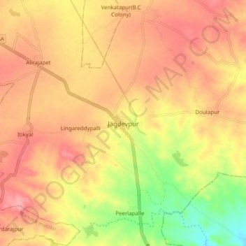
Name: Topografische Karte Jagdevpur, Höhe, Relief.
Durchschnittliche Höhe: 546 m
Minimale Höhe: 484 m
Maximale Höhe: 583 m