
Topografische Karte Hartswater
Interaktive Karte
Klicken Sie auf die Karte, um die Höhe anzuzeigen.
Über diese Karte
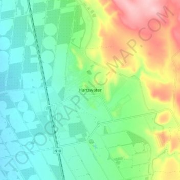
Name: Topografische Karte Hartswater, Höhe, Relief.
Durchschnittliche Höhe: 1.146 m
Minimale Höhe: 1.093 m
Maximale Höhe: 1.257 m
Andere topografische Karten
Klicken Sie auf eine Karte, um ihre Topografie, ihre Höhe und ihr Relief anzuzeigen.
Phokwane Local Municipality
South Africa > Northern Cape > Frances Baard District Municipality > Phokwane Local Municipality
Phokwane Local Municipality, Frances Baard District Municipality, Northern Cape, South Africa
Durchschnittliche Höhe: 1.174 m
Jan Kempdorp
South Africa > Northern Cape > Frances Baard District Municipality > Phokwane Local Municipality
Jan Kempdorp, Phokwane Local Municipality, Frances Baard District Municipality, Northern Cape, 8550, South Africa
Durchschnittliche Höhe: 1.157 m