
Topografische Karte Salen
Interaktive Karte
Klicken Sie auf die Karte, um die Höhe anzuzeigen.
Über diese Karte
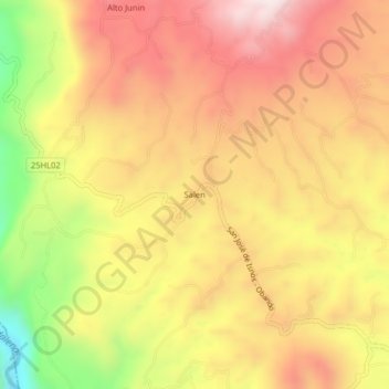
Name: Topografische Karte Salen, Höhe, Relief.
Ort: Salen, Isnos, Sur, Huila, RAP (Especial) Central, Colombia (1.92170 -76.28026 1.96170 -76.24026)
Durchschnittliche Höhe: 1.811 m
Minimale Höhe: 1.392 m
Maximale Höhe: 2.104 m
Andere topografische Karten
Klicken Sie auf eine Karte, um ihre Topografie, ihre Höhe und ihr Relief anzuzeigen.
Isnos Huila
Isnos Huila, Isnos, Sur, Huila, RAP (Especial) Central, Colombia
Durchschnittliche Höhe: 1.782 m
La Muralla
La Muralla, Isnos, Sur, Huila, RAP (Especial) Central, Colombia
Durchschnittliche Höhe: 1.714 m
El Mortiño
El Mortiño, Isnos, Sur, Huila, RAP (Especial) Central, 418060, Colombia
Durchschnittliche Höhe: 1.591 m
Parque Nacional Natural Puracé
Parque Nacional Natural Puracé, Isnos, Sur, Huila, RAP (Especial) Central, Colombia
Durchschnittliche Höhe: 2.708 m
Paloquemao
Paloquemao, Isnos, Sur, Huila, RAP (Especial) Central, Colombia
Durchschnittliche Höhe: 2.152 m