
Topografische Karte Matagorda County
Interaktive Karte
Klicken Sie auf die Karte, um die Höhe anzuzeigen.
Über diese Karte
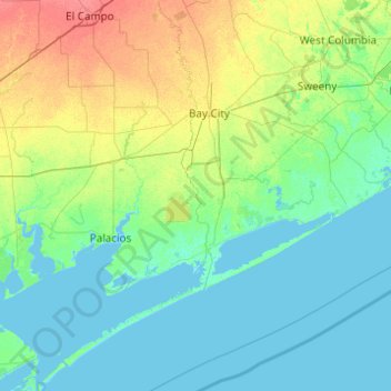
Name: Topografische Karte Matagorda County, Höhe, Relief.
Ort: Matagorda County, Texas, United States (28.29223 -96.38043 29.22977 -95.42099)
Durchschnittliche Höhe: 8 m
Minimale Höhe: -2 m
Maximale Höhe: 38 m
Andere topografische Karten
Klicken Sie auf eine Karte, um ihre Topografie, ihre Höhe und ihr Relief anzuzeigen.
Baxter Island
United States > Texas > Matagorda County
Baxter Island, Matagorda County, Texas, 77415, United States
Durchschnittliche Höhe: 4 m
Ashwood
United States > Texas > Matagorda County > Ashwood
Ashwood, Matagorda County, Texas, United States
Durchschnittliche Höhe: 16 m