
Topografische Karte White Hills Subdivision
Interaktive Karte
Klicken Sie auf die Karte, um die Höhe anzuzeigen.
Über diese Karte
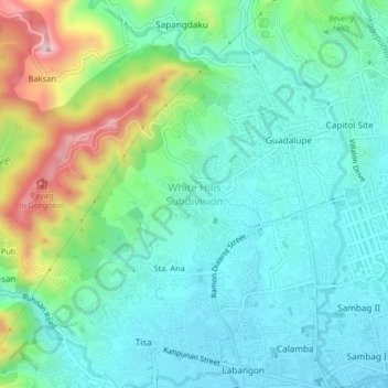
Name: Topografische Karte White Hills Subdivision, Höhe, Relief.
Durchschnittliche Höhe: 97 m
Minimale Höhe: 7 m
Maximale Höhe: 356 m
Andere topografische Karten
Klicken Sie auf eine Karte, um ihre Topografie, ihre Höhe und ihr Relief anzuzeigen.
Sta. Ana
Sta. Ana, Cebu City, Central Visayas, 6000, Philippines
Durchschnittliche Höhe: 85 m
To-ong
To-ong, Cebu City, Central Visayas, Philippines
Durchschnittliche Höhe: 224 m
Udlom
Philippines > Cebu City > Sinsin
Udlom, Sinsin, Cebu City, Central Visayas, Philippines
Durchschnittliche Höhe: 491 m
Citylights Gardens
Citylights Gardens, Cebu City, Central Visayas, 6666, Philippines
Durchschnittliche Höhe: 115 m
Kawit Island
Kawit Island, Cebu City, Central Visayas, 6000, Philippines
Durchschnittliche Höhe: 1 m
Sirao Peak
Sirao Peak, Cebu City, Central Visayas, Philippines
Durchschnittliche Höhe: 493 m
Buhisan Dam
Philippines > Cebu City > Puti
Buhisan Dam, Buhisan Water Reservoir, Puti, Cebu City, Central Visayas, 6000, Philippines
Durchschnittliche Höhe: 221 m
Guadalupe River
Guadalupe River, Guadalupe, Cebu City, Central Visayas, 6000, Philippines
Durchschnittliche Höhe: 49 m
Piazza Elesia
Piazza Elesia, Cebu City, Central Visayas, 6014, Philippines
Durchschnittliche Höhe: 69 m
Mt. Babag
Mt. Babag, Cebu City, Central Visayas, Philippines
Durchschnittliche Höhe: 476 m
Sudlon II
Philippines > Cebu City > Sudlon II
Sudlon II, Cebu City, Central Visayas, Philippines
Durchschnittliche Höhe: 634 m
Sinsin
Philippines > Cebu City > Sinsin
Sinsin, Cebu City, Central Visayas, Philippines
Durchschnittliche Höhe: 471 m
Banilad Streetscape
Banilad Streetscape, Cebu City, Central Visayas, 6666, Philippines
Durchschnittliche Höhe: 68 m
Pahina San Nicolas
Philippines > Cebu City > Pahina San Nicolas
Pahina San Nicolas, Cebu City, Central Visayas, 65012, Philippines
Durchschnittliche Höhe: 8 m
Central
Philippines > Cebu City > Central
Central, Cebu City, Central Visayas, 65012, Philippines
Durchschnittliche Höhe: 7 m