
Topografische Karte Upington
Interaktive Karte
Klicken Sie auf die Karte, um die Höhe anzuzeigen.
Über diese Karte
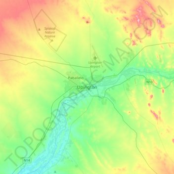
Name: Topografische Karte Upington, Höhe, Relief.
Durchschnittliche Höhe: 849 m
Minimale Höhe: 765 m
Maximale Höhe: 1.006 m
The elevation of Upington is 2,742 feet (835 metres). It is the closest large centre to the Augrabies Falls (arguably the greatest of South African waterfalls) and the Kgalagadi Transfrontier Park. The landscape is very arid but the soil is fertile and crops such as fruit are grown in irrigated fields. The area is best known for its export-quality grapes, raisins and wines, which are cultivated on the rich flood plains of the Orange River.
Andere topografische Karten
Klicken Sie auf eine Karte, um ihre Topografie, ihre Höhe und ihr Relief anzuzeigen.
Donkie-ieland
South Africa > Northern Cape > ZF Mgcawu District Municipality > Kai !Garib Local Municipality
Donkie-ieland, Kai !Garib Local Municipality, ZF Mgcawu District Municipality, Northern Cape, South Africa
Durchschnittliche Höhe: 772 m
Rietfontein
South Africa > Northern Cape > ZF Mgcawu District Municipality > Mier Local Municipality
Rietfontein, Mier Ward 3, Mier Local Municipality, ZF Mgcawu District Municipality, Northern Cape, South Africa
Durchschnittliche Höhe: 849 m
Daniëlskuil
South Africa > Northern Cape > ZF Mgcawu District Municipality > Kgatelopele Local Municipality
Daniëlskuil, Kgatelopele Local Municipality, ZF Mgcawu District Municipality, Northern Cape, South Africa
Durchschnittliche Höhe: 1.479 m