
Topografische Karte Cartagena
Interaktive Karte
Klicken Sie auf die Karte, um die Höhe anzuzeigen.
Über diese Karte
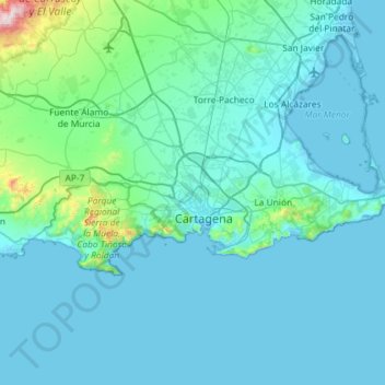
Name: Topografische Karte Cartagena, Höhe, Relief.
Durchschnittliche Höhe: 70 m
Minimale Höhe: -5 m
Maximale Höhe: 1.060 m
Cartagena's coastal mountains have one of the highest levels of botanical biodiversity on the Iberian Peninsula. A number of surprising Ibero-African species, which are found only in southern Spain (mostly in the provinces of Murcia and Almería) and North Africa. Among these, there stands out Tetraclinis articulata or Sandarac (sabina mora or ciprés de Cartagena —Cartagena cypress in Spanish) native to Morocco, Algeria, Tunisia, Malta, and Cartagena, growing at relatively low altitudes in a hot, dry Mediterranean woodland. Some species are seriously endangered like the siempreviva de Cartagena (Limonium carthaginense), the rabogato del Mar Menor (Sideritis marmironensis), the zamarrilla de Cartagena (Teucrium carthaginense), the manzanilla de Escombreras (Anthemis chrysantha), the garbancillo de Tallante (Astragalus nitidiflorus), the jara de Cartagena (Cistus heterophyllus carthaginensis) and the varica de San José (Narcissus tortifolius).
Andere topografische Karten
Klicken Sie auf eine Karte, um ihre Topografie, ihre Höhe und ihr Relief anzuzeigen.
Los Alcázares
Spain > Region of Murcia > Campo de Cartagena y Mar Menor
Los Alcázares, Campo de Cartagena y Mar Menor, Region of Murcia, 30710, Spain
Durchschnittliche Höhe: 9 m
San Javier
Spain > Region of Murcia > Campo de Cartagena y Mar Menor
San Javier, Campo de Cartagena y Mar Menor, Region of Murcia, Spain
Durchschnittliche Höhe: 29 m