
Topografische Karte Village of Lake Placid
Interaktive Karte
Klicken Sie auf die Karte, um die Höhe anzuzeigen.
Über diese Karte
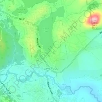
Name: Topografische Karte Village of Lake Placid, Höhe, Relief.
Durchschnittliche Höhe: 558 m
Minimale Höhe: 507 m
Maximale Höhe: 701 m
Lake Placid is well known among winter-sports enthusiasts for its skiing, both Alpine and Nordic. Whiteface Mountain (4,867 ft or 1,483 m), in nearby Wilmington about 13 miles (21 km) from Lake Placid, offers skiing, hiking, gondola rides, and mountain biking, and is the only one of the High Peaks that can be reached by an auto road. Whiteface Mountain has a vertical elevation of 3,430 feet (1,050 m), the highest vertical elevation of mountains in Eastern North America. The area has one of only 16 bobsled runs in the Western Hemisphere.
Andere topografische Karten
Klicken Sie auf eine Karte, um ihre Topografie, ihre Höhe und ihr Relief anzuzeigen.
Town of Newcomb
United States > New York > Essex County
Town of Newcomb, Essex County, New York, 12852, United States
Durchschnittliche Höhe: 627 m
Brown Mountain
United States > New York > Essex County > Keene
Brown Mountain, Keene, Essex County, New York, 12942, United States
Durchschnittliche Höhe: 488 m
Town of Keene
United States > New York > Essex County
Town of Keene, Essex County, New York, United States, Saddleback Mountain
Durchschnittliche Höhe: 1.113 m
Mount Lewis
United States > New York > Essex County > Crown Point
Mount Lewis, Crown Point, Essex County, New York, United States
Durchschnittliche Höhe: 350 m