
Topografische Karte Monsey
Interaktive Karte
Klicken Sie auf die Karte, um die Höhe anzuzeigen.
Über diese Karte
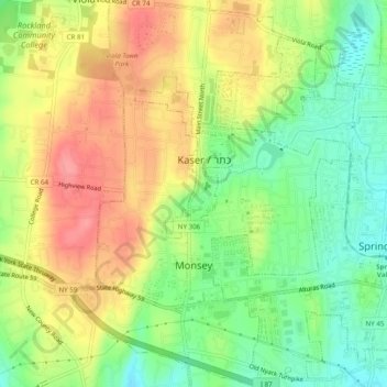
Name: Topografische Karte Monsey, Höhe, Relief.
Durchschnittliche Höhe: 172 m
Minimale Höhe: 132 m
Maximale Höhe: 214 m
Andere topografische Karten
Klicken Sie auf eine Karte, um ihre Topografie, ihre Höhe und ihr Relief anzuzeigen.
Fort Clinton
United States > New York > Rockland County > Town of Stony Point
Fort Clinton, Town of Stony Point, Rockland County, New York, 10922, United States
Durchschnittliche Höhe: 111 m
Village of Chestnut Ridge
United States > New York > Rockland County
Village of Chestnut Ridge, Town of Ramapo, Rockland County, New York, United States
Durchschnittliche Höhe: 127 m
Buckberg
United States > New York > Rockland County > Town of Stony Point
Buckberg, Town of Stony Point, Rockland County, New York, 10986, United States
Durchschnittliche Höhe: 108 m
Blauvelt
United States > New York > Rockland County
Blauvelt, Town of Orangetown, Rockland County, New York, 10913, United States
Durchschnittliche Höhe: 63 m
Garnerville
United States > New York > Rockland County > Village of West Haverstraw
Garnerville, Village of West Haverstraw, Town of Haverstraw, Rockland County, New York, 10923, United States
Durchschnittliche Höhe: 80 m
Antrim
United States > New York > Rockland County > Town of Ramapo > Village of Suffern
Antrim, Village of Suffern, Town of Ramapo, Rockland County, New York, 10901, United States
Durchschnittliche Höhe: 140 m
Suffern
United States > New York > Rockland County > Suffern > Suffern
Suffern, Town of Ramapo, Rockland County, New York, 07495, United States
Durchschnittliche Höhe: 159 m