
Topografische Karte Gangotri National Park
Interaktive Karte
Klicken Sie auf die Karte, um die Höhe anzuzeigen.
Gangotri National Park
The park harbors Western Himalayan subalpine conifer forests at lower elevations and Western Himalayan alpine shrub and meadows at higher elevations. Vegetation consist of chirpine deodar, fir, spruce, oak and rhododendrons.
Über diese Karte
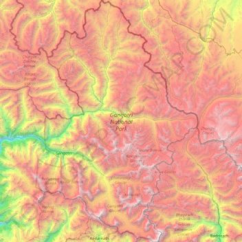
Name: Topografische Karte Gangotri National Park, Höhe, Relief.
Durchschnittliche Höhe: 5.008 m
Minimale Höhe: 2.497 m
Maximale Höhe: 7.135 m
Andere topografische Karten
Klicken Sie auf eine Karte, um ihre Topografie, ihre Höhe und ihr Relief anzuzeigen.
Uttarkashi
India > Uttarakhand > Bhatwari
It is the district headquarters of Uttarkashi district. Uttarkashi is situated on the banks of river Bhagirathi at an altitude of 1158 m above sea level. Uttarkashi is generally known as a holy town close to Rishikesh. It is located in the state of Uttarakhand in India. Uttarkashi is home to a number of…
Durchschnittliche Höhe: 1.619 m