
Topografische Karte Mińsk County
Interaktive Karte
Klicken Sie auf die Karte, um die Höhe anzuzeigen.
Über diese Karte
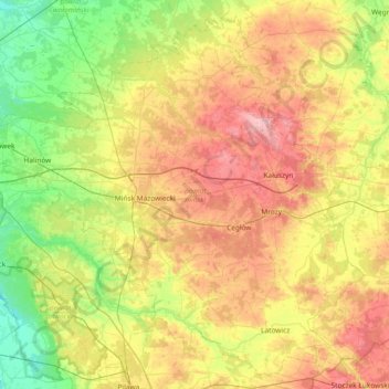
Name: Topografische Karte Mińsk County, Höhe, Relief.
Ort: Mińsk County, Masovian Voivodeship, Poland (51.97357 21.23795 52.39501 21.97992)
Durchschnittliche Höhe: 143 m
Minimale Höhe: 87 m
Maximale Höhe: 225 m
Andere topografische Karten
Klicken Sie auf eine Karte, um ihre Topografie, ihre Höhe und ihr Relief anzuzeigen.
Konstancin-Jeziorna
Poland > Masovian Voivodeship > Piaseczno County > Konstancin-Jeziorna
Konstancin-Jeziorna, gmina Konstancin-Jeziorna, Piaseczno County, Masovian Voivodeship, 05-510, Poland
Durchschnittliche Höhe: 96 m
Warsaw
Poland > Masovian Voivodeship > Warsaw > Warsaw
Warsaw, Masovian Voivodeship, 00-901, Poland
Durchschnittliche Höhe: 95 m
Węgrów
Poland > Masovian Voivodeship > Węgrów
Węgrów, Węgrów County, Masovian Voivodeship, 07-100, Poland
Durchschnittliche Höhe: 138 m
Praga-Południe
Poland > Masovian Voivodeship > Warsaw
Praga-Południe, Warsaw, Warszawa, Masovian Voivodeship, Poland
Durchschnittliche Höhe: 86 m
Warsaw
Poland > Masovian Voivodeship > Warsaw
Warsaw, Masovian Voivodeship, Poland
Durchschnittliche Höhe: 96 m
Radom
Poland > Masovian Voivodeship > Radom
Radom, Masovian Voivodeship, Poland
Durchschnittliche Höhe: 168 m