
Topografische Karte Swift Trail Junction
Interaktive Karte
Klicken Sie auf die Karte, um die Höhe anzuzeigen.
Über diese Karte
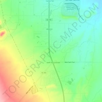
Name: Topografische Karte Swift Trail Junction, Höhe, Relief.
Durchschnittliche Höhe: 984 m
Minimale Höhe: 932 m
Maximale Höhe: 1.073 m
Swift Trail Junction is a census-designated place (CDP) in Graham County, Arizona, United States. The population was 2,935 at the 2010 census, up from 2,195 in 2000. It is part of the Safford Micropolitan Statistical Area. It is situated at the junction of U.S. Route 191 and State Route 366 (also known as the Swift Trail Parkway). The Swift Trail Parkway is a scenic highway that winds through the Coronado National Forest and provides access to the higher elevations of the Pinaleño Mountains, also known as the Graham Mountains.
Andere topografische Karten
Klicken Sie auf eine Karte, um ihre Topografie, ihre Höhe und ihr Relief anzuzeigen.
Eden
United States > Arizona > Graham County
Eden, Graham County, Arizona, 85535, United States
Durchschnittliche Höhe: 850 m
Thatcher
United States > Arizona > Graham County
Thatcher, Graham County, Arizona, 85552, United States
Durchschnittliche Höhe: 912 m
Artesia
United States > Arizona > Graham County
Artesia, Graham County, Arizona, United States
Durchschnittliche Höhe: 1.018 m
Mount Graham
United States > Arizona > Graham County
Mount Graham, Graham County, Arizona, United States
Durchschnittliche Höhe: 2.957 m
Safford
United States > Arizona > Graham County
Safford, Graham County, Arizona, United States
Durchschnittliche Höhe: 912 m
Safford
United States > Arizona > Graham County > Safford
Safford, Graham County, Arizona, 85548, United States
Durchschnittliche Höhe: 1.113 m
Thumb Butte
United States > Arizona > Graham County
Thumb Butte, Graham County, Arizona, United States
Durchschnittliche Höhe: 1.481 m
Quartzite Mountain
United States > Arizona > Graham County
Quartzite Mountain, Graham County, Arizona, United States
Durchschnittliche Höhe: 1.574 m