
Topografische Karte Horseshoe Bend
Interaktive Karte
Klicken Sie auf die Karte, um die Höhe anzuzeigen.
Über diese Karte
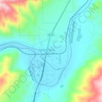
Name: Topografische Karte Horseshoe Bend, Höhe, Relief.
Ort: Horseshoe Bend, Boise County, Idaho, United States (43.89845 -116.21011 43.92994 -116.18873)
Durchschnittliche Höhe: 867 m
Minimale Höhe: 784 m
Maximale Höhe: 1.125 m
The area was originally settled as a gold miners' staging area, as prospectors waited along the river for snows to thaw at the higher elevations. Gold had been discovered in 1862 in the Boise Basin mountains to the east, near Idaho City.
Andere topografische Karten
Klicken Sie auf eine Karte, um ihre Topografie, ihre Höhe und ihr Relief anzuzeigen.
Placerville
United States > Idaho > Boise County
Placerville, Boise County, Idaho, 83666, United States
Durchschnittliche Höhe: 1.343 m
Hawley Mountain
United States > Idaho > Boise County
Hawley Mountain, Boise County, Idaho, United States
Durchschnittliche Höhe: 2.023 m
Idaho City
United States > Idaho > Boise County
Idaho City, Boise County, Idaho, 83631, United States
Durchschnittliche Höhe: 1.236 m
North Raker
United States > Idaho > Boise County
North Raker, Boise County, Idaho, United States
Durchschnittliche Höhe: 2.651 m
Garden Valley
United States > Idaho > Boise County
Garden Valley, Boise County, Idaho, 83622, United States
Durchschnittliche Höhe: 1.004 m