
Topografische Karte Hills Park
Interaktive Karte
Klicken Sie auf die Karte, um die Höhe anzuzeigen.
Über diese Karte
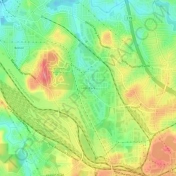
Name: Topografische Karte Hills Park, Höhe, Relief.
Durchschnittliche Höhe: 269 m
Minimale Höhe: 231 m
Maximale Höhe: 314 m
Andere topografische Karten
Klicken Sie auf eine Karte, um ihre Topografie, ihre Höhe und ihr Relief anzuzeigen.
Bolton
United States > Georgia > Fulton County > Atlanta
Bolton, Atlanta, Fulton County, Georgia, 30369, United States
Durchschnittliche Höhe: 259 m
Atlanta Memorial Park
United States > Georgia > Fulton County > Atlanta
Atlanta Memorial Park, Atlanta, Fulton County, Georgia, United States
Durchschnittliche Höhe: 263 m
Piedmont Park
United States > Georgia > Fulton County > Atlanta
Piedmont Park, Atlanta, Fulton County, Georgia, 30306, United States
Durchschnittliche Höhe: 283 m
Capital City Country Club Lake Dam
United States > Georgia > Fulton County > Atlanta
Capital City Country Club Lake Dam, Atlanta, Fulton County, Georgia, 30319, United States
Durchschnittliche Höhe: 294 m
Simsville
United States > Georgia > Fulton County > Atlanta > Simsville
Simsville, Atlanta, Fulton County, Georgia, 30318, United States
Durchschnittliche Höhe: 275 m
Egan Park
United States > Georgia > Fulton County > Atlanta > Egan Park
Egan Park, Atlanta, Fulton County, Georgia, 30344, United States
Durchschnittliche Höhe: 307 m
Blair Village
United States > Georgia > Fulton County > Atlanta
Blair Village, Atlanta, Fulton County, Georgia, 30304, United States
Durchschnittliche Höhe: 275 m