
Topografische Karte Stonehurst
Interaktive Karte
Klicken Sie auf die Karte, um die Höhe anzuzeigen.
Über diese Karte
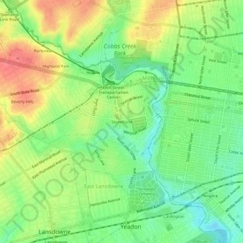
Name: Topografische Karte Stonehurst, Höhe, Relief.
Durchschnittliche Höhe: 41 m
Minimale Höhe: 10 m
Maximale Höhe: 79 m
Andere topografische Karten
Klicken Sie auf eine Karte, um ihre Topografie, ihre Höhe und ihr Relief anzuzeigen.
Highland Park
United States > Pennsylvania > Delaware County > Upper Darby
Highland Park, Upper Darby, Delaware County, Pennsylvania, 19082, United States
Durchschnittliche Höhe: 55 m
Drexel Hill
United States > Pennsylvania > Delaware County > Upper Darby
Drexel Hill, Upper Darby, Delaware County, Pennsylvania, 19026, United States
Durchschnittliche Höhe: 58 m
Beverly Hills
United States > Pennsylvania > Delaware County > Upper Darby > Beverly Hills
Beverly Hills, Upper Darby, Delaware County, Pennsylvania, 19082, United States
Durchschnittliche Höhe: 56 m
Addingham
United States > Pennsylvania > Delaware County > Upper Darby
Addingham, Upper Darby, Delaware County, Pennsylvania, 19026, United States
Durchschnittliche Höhe: 62 m