
Topografische Karte Huntington Station
Interaktive Karte
Klicken Sie auf die Karte, um die Höhe anzuzeigen.
Über diese Karte
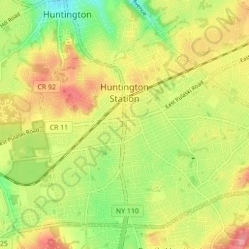
Name: Topografische Karte Huntington Station, Höhe, Relief.
Durchschnittliche Höhe: 60 m
Minimale Höhe: 17 m
Maximale Höhe: 101 m
Andere topografische Karten
Klicken Sie auf eine Karte, um ihre Topografie, ihre Höhe und ihr Relief anzuzeigen.
East Northport
United States > New York > Suffolk County > Town of Huntington
East Northport, Town of Huntington, Suffolk County, New York, 11731, United States
Durchschnittliche Höhe: 54 m
Commack
United States > New York > Suffolk County > Town of Huntington
Commack, Town of Huntington, Suffolk County, New York, 11725, United States
Durchschnittliche Höhe: 51 m
Eatons Neck
United States > New York > Suffolk County > Town of Huntington
Eatons Neck, Town of Huntington, Suffolk County, New York, United States
Durchschnittliche Höhe: 5 m
Village of Lloyd Harbor
United States > New York > Suffolk County > Town of Huntington
Village of Lloyd Harbor, Town of Huntington, Suffolk County, New York, United States
Durchschnittliche Höhe: 14 m