
Topografische Karte Chatham County
Interaktive Karte
Klicken Sie auf die Karte, um die Höhe anzuzeigen.
Über diese Karte
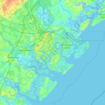
Name: Topografische Karte Chatham County, Höhe, Relief.
Ort: Chatham County, Georgia, United States (31.70520 -81.39170 32.23759 -80.75143)
Durchschnittliche Höhe: 3 m
Minimale Höhe: -5 m
Maximale Höhe: 28 m
Andere topografische Karten
Klicken Sie auf eine Karte, um ihre Topografie, ihre Höhe und ihr Relief anzuzeigen.
Fort Pulaski
United States > Georgia > Chatham County
Fort Pulaski, Fort Perimeter Trail, Chatham County, Georgia, 31328, United States
Durchschnittliche Höhe: 1 m
Moon River
United States > Georgia > Chatham County > Burnside View
Moon River, Burnside View, Chatham County, Georgia, 31411, United States
Durchschnittliche Höhe: 2 m
Tybee Island
United States > Georgia > Chatham County
Tybee Island, Chatham County, Georgia, 31328, United States
Durchschnittliche Höhe: 1 m
Savannah
United States > Georgia > Chatham County
Savannah, Chatham County, Georgia, United States
Durchschnittliche Höhe: 4 m