
Topografische Karte Chattanooga
Interaktive Karte
Klicken Sie auf die Karte, um die Höhe anzuzeigen.
Über diese Karte
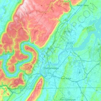
Name: Topografische Karte Chattanooga, Höhe, Relief.
Durchschnittliche Höhe: 331 m
Minimale Höhe: 189 m
Maximale Höhe: 722 m
The city, with a downtown elevation of about 680 feet (210 m), is at the transition between the ridge-and-valley portion of the Appalachian Mountains and the Cumberland Plateau. Its official nickname is "Scenic City", alluding to the surrounding by mountains and ridges. Unofficial nicknames include "River City", "Chatt", "Nooga", "Chattown", and "Gig City", the latter a reference to Chattanooga's claims that it has the fastest internet service in the Western Hemisphere.
Andere topografische Karten
Klicken Sie auf eine Karte, um ihre Topografie, ihre Höhe und ihr Relief anzuzeigen.
Signal Mountain
United States > Tennessee > Hamilton County
Signal Mountain, Hamilton County, East Tennessee, Tennessee, 37377, United States
Durchschnittliche Höhe: 493 m
East Lake
United States > Tennessee > Hamilton County > Chattanooga > East Ridge
East Lake, East Ridge, Chattanooga, Hamilton County, East Tennessee, Tennessee, 37407, United States
Durchschnittliche Höhe: 231 m
Battery Heights
United States > Tennessee > Hamilton County > Chattanooga
Battery Heights, Chattanooga, Hamilton County, Tennessee, 37406, United States
Durchschnittliche Höhe: 221 m
Old Farm
United States > Tennessee > Hamilton County > Chattanooga
Old Farm, Chattanooga, Hamilton County, Tennessee, 37419, United States
Durchschnittliche Höhe: 261 m
East Brainerd
United States > Tennessee > Hamilton County > Chattanooga
East Brainerd, Chattanooga, Hamilton County, Tennessee, 30726, United States
Durchschnittliche Höhe: 225 m
Ooltewah
United States > Tennessee > Hamilton County
Ooltewah, Hamilton County, East Tennessee, Tennessee, United States
Durchschnittliche Höhe: 267 m