
Topografische Karte Dipaleseng Local Municipality
Interaktive Karte
Klicken Sie auf die Karte, um die Höhe anzuzeigen.
Über diese Karte
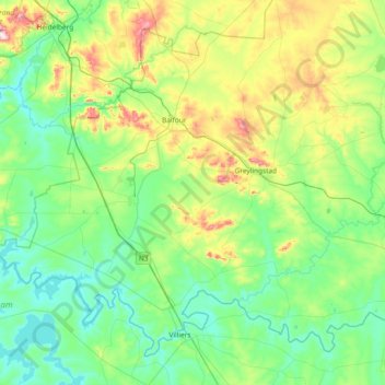
Name: Topografische Karte Dipaleseng Local Municipality, Höhe, Relief.
Durchschnittliche Höhe: 1.574 m
Minimale Höhe: 1.478 m
Maximale Höhe: 1.899 m
Andere topografische Karten
Klicken Sie auf eine Karte, um ihre Topografie, ihre Höhe und ihr Relief anzuzeigen.
Balfour
South Africa > Mpumalanga > Gert Sibande > Dipaleseng Local Municipality
Balfour, Dipaleseng Local Municipality, Gert Sibande, Mpumalanga, 2410, South Africa
Durchschnittliche Höhe: 1.636 m
Greylingstad
South Africa > Mpumalanga > Gert Sibande > Dipaleseng Local Municipality
Greylingstad, Dipaleseng Local Municipality, Gert Sibande, Mpumalanga, 2415, South Africa
Durchschnittliche Höhe: 1.635 m