
Topografische Karte Falmouth
Interaktive Karte
Klicken Sie auf die Karte, um die Höhe anzuzeigen.
Über diese Karte
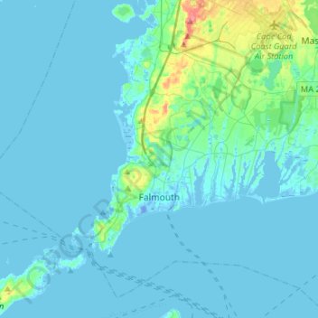
Name: Topografische Karte Falmouth, Höhe, Relief.
Ort: Falmouth, Barnstable County, Massachusetts, United States (41.48914 -70.76063 41.66039 -70.49800)
Durchschnittliche Höhe: 7 m
Minimale Höhe: -19 m
Maximale Höhe: 72 m
Falmouth's topography is similar to the rest of Cape Cod's, with many small ponds, creeks, and inlets surrounded by the pines and oaks of the Cape and often rocky beachfront. Falmouth's southern shore is notable for a series of ponds and rivers spaced very closely together, all of which travel some distance into the town. These include, from west to east, Falmouth Inner Harbor, Little Pond, Great Pond (which leads to the Dexter and Coonamesset rivers), Green Pond, Bourne's Pond, Eel Pond (which leads to the Childs River), and Waquoit Bay, which lies along the Mashpee town line. The Buzzards Bay side of the town is primarily bays divided by necks, peninsulas connected to land by isthmi. The largest inlet is Megansett Cove along the Bourne town line. The Buzzards Bay shore of Falmouth is punctuated by a number of hamlets, including, from north to south, Megansett, New Silver Beach, Old Silver, Chappaquoit, Sippewisset, Quissett, and Woods Hole.
Andere topografische Karten
Klicken Sie auf eine Karte, um ihre Topografie, ihre Höhe und ihr Relief anzuzeigen.
Shank Painter Pond
United States > Massachusetts > Barnstable County > Provincetown
Shank Painter Pond, West End, Provincetown, Barnstable County, Massachusetts, United States
Durchschnittliche Höhe: 4 m
Harwich
United States > Massachusetts > Barnstable County
Harwich, Barnstable County, Massachusetts, United States
Durchschnittliche Höhe: 7 m
Barlows Landing
United States > Massachusetts > Barnstable County > Bourne
Barlows Landing, Bourne, Barnstable County, Massachusetts, 02559, United States
Durchschnittliche Höhe: 6 m
Mt. Perry
United States > Massachusetts > Barnstable County > Bourne
Mt. Perry, Bourne, Barnstable County, Massachusetts, 02561, United States
Durchschnittliche Höhe: 34 m
Mayflower Heights
United States > Massachusetts > Barnstable County > Provincetown
Mayflower Heights, Provincetown, Barnstable County, Massachusetts, 02657, United States
Durchschnittliche Höhe: 2 m
Barnstable
United States > Massachusetts > Barnstable County
Barnstable, Barnstable County, Massachusetts, United States
Durchschnittliche Höhe: 7 m
Harwich Port
United States > Massachusetts > Barnstable County > Harwich > Harwich Port
Harwich Port, Harwich, Barnstable County, Massachusetts, 02646, United States
Durchschnittliche Höhe: 3 m
East Brewster
United States > Massachusetts > Barnstable County > Brewster > East Brewster
East Brewster, Brewster, Barnstable County, Massachusetts, 02631, United States
Durchschnittliche Höhe: 16 m