
Topografische Karte Kielce County
Interaktive Karte
Klicken Sie auf die Karte, um die Höhe anzuzeigen.
Über diese Karte
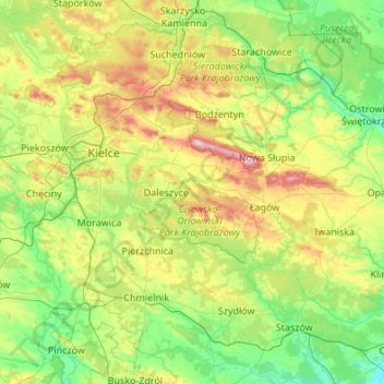
Name: Topografische Karte Kielce County, Höhe, Relief.
Ort: Kielce County, Holy Cross Voivodeship, Poland (50.53648 20.09240 51.06666 21.17416)
Durchschnittliche Höhe: 263 m
Minimale Höhe: 153 m
Maximale Höhe: 603 m
Andere topografische Karten
Klicken Sie auf eine Karte, um ihre Topografie, ihre Höhe und ihr Relief anzuzeigen.
Kaliga
Poland > Holy Cross Voivodeship > Końskie County
Kaliga, gmina Radoszyce, Końskie County, Holy Cross Voivodeship, Poland
Durchschnittliche Höhe: 250 m
Chrusty
Poland > Holy Cross Voivodeship > Busko County > Żerniki Górne
Chrusty, Żerniki Górne, gmina Busko-Zdrój, Busko County, Holy Cross Voivodeship, Poland
Durchschnittliche Höhe: 257 m
Mściów
Poland > Holy Cross Voivodeship > Sandomierz County
Mściów, gmina Dwikozy, Sandomierz County, Holy Cross Voivodeship, Poland
Durchschnittliche Höhe: 150 m
Ciekoty
Poland > Holy Cross Voivodeship > Kielce County
Ciekoty, gmina Masłów, Kielce County, Holy Cross Voivodeship, Poland
Durchschnittliche Höhe: 310 m
Opatów
Poland > Holy Cross Voivodeship > Opatów County
Opatów, gmina Opatów, Opatów County, Holy Cross Voivodeship, 27-500, Poland
Durchschnittliche Höhe: 242 m