
Topografische Karte New River
Interaktive Karte
Klicken Sie auf die Karte, um die Höhe anzuzeigen.
Über diese Karte
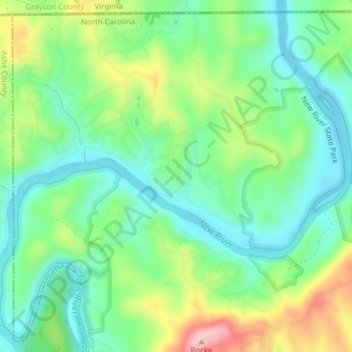
Name: Topografische Karte New River, Höhe, Relief.
Durchschnittliche Höhe: 803 m
Minimale Höhe: 742 m
Maximale Höhe: 928 m
On its journey through the New River Gorge, the New River passes through an extensive geological formation. Emergent rocks and rock outcrops are found to provide diverse habitat producing rich and abundant flora and fauna species. In the gorge, there is typically a 1000 feet difference in elevation between the river bottom and the adjacent plateau. The New River dissects all physiographic provinces of the Appalachian Mountains, and therefore is believed to be a corridor facilitating the movement of southern plant and animal species into West Virginia. In addition to serving as a refuge for some species, New River Gorge provides a geographical barrier that limits the east-west distribution of other species.
Andere topografische Karten
Klicken Sie auf eine Karte, um ihre Topografie, ihre Höhe und ihr Relief anzuzeigen.
Sparta
United States > North Carolina > Alleghany County
Sparta, Alleghany County, North Carolina, 28675, United States
Durchschnittliche Höhe: 893 m
Camp Cheerio Dam
United States > North Carolina > Alleghany County
Camp Cheerio Dam, Alleghany County, North Carolina, 28668, United States
Durchschnittliche Höhe: 813 m
Glade Valley
United States > North Carolina > Alleghany County
Glade Valley, Alleghany County, North Carolina, 28627, United States
Durchschnittliche Höhe: 837 m
Piney Creek
United States > North Carolina > Alleghany County
Piney Creek, Alleghany County, North Carolina, 28663, United States
Durchschnittliche Höhe: 839 m
Little River
United States > North Carolina > Alleghany County > Sparta
Little River, Sparta, Alleghany County, North Carolina, 28675, United States
Durchschnittliche Höhe: 865 m
Topia
United States > North Carolina > Alleghany County > Topia
Topia, Alleghany County, North Carolina, 28663, United States
Durchschnittliche Höhe: 830 m
Roaring Gap
United States > North Carolina > Alleghany County
Roaring Gap, Alleghany County, North Carolina, 28668, United States
Durchschnittliche Höhe: 840 m
Ennice
United States > North Carolina > Alleghany County
Ennice, Alleghany County, North Carolina, 28623, United States
Durchschnittliche Höhe: 794 m
Laurel Springs
United States > North Carolina > Alleghany County
Laurel Springs, Alleghany County, North Carolina, 28644, United States
Durchschnittliche Höhe: 893 m