
Topografische Karte Amsbury
Interaktive Karte
Klicken Sie auf die Karte, um die Höhe anzuzeigen.
Über diese Karte
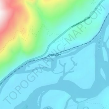
Name: Topografische Karte Amsbury, Höhe, Relief.
Durchschnittliche Höhe: 205 m
Minimale Höhe: 30 m
Maximale Höhe: 1.152 m
Andere topografische Karten
Klicken Sie auf eine Karte, um ihre Topografie, ihre Höhe und ihr Relief anzuzeigen.
Lakelse
Canada > British Columbia > Regional District of Kitimat-Stikine > Area C (Butedale/Kitlope/Kitsumkalum)
Lakelse, Area C (Butedale/Kitlope/Kitsumkalum), Regional District of Kitimat-Stikine, British Columbia, V8G 0G2, Canada
Durchschnittliche Höhe: 213 m
Mount Clore
Canada > British Columbia > Regional District of Kitimat-Stikine > Area C (Butedale/Kitlope/Kitsumkalum)
Mount Clore, Area C (Butedale/Kitlope/Kitsumkalum), Regional District of Kitimat-Stikine, British Columbia, Canada
Durchschnittliche Höhe: 1.602 m
Milne Island
Canada > British Columbia > Regional District of Kitimat-Stikine > Area C (Butedale/Kitlope/Kitsumkalum)
Milne Island, Area C (Butedale/Kitlope/Kitsumkalum), Regional District of Kitimat-Stikine, British Columbia, Canada
Durchschnittliche Höhe: 9 m