
Topografische Karte South Berwick
Interaktive Karte
Klicken Sie auf die Karte, um die Höhe anzuzeigen.
Über diese Karte
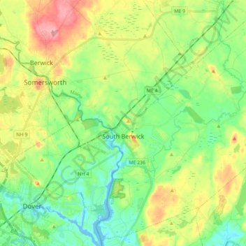
Name: Topografische Karte South Berwick, Höhe, Relief.
Ort: South Berwick, York County, Maine, 03908, United States (43.17975 -70.82830 43.30243 -70.65291)
Durchschnittliche Höhe: 46 m
Minimale Höhe: -8 m
Maximale Höhe: 127 m
According to the United States Census Bureau, the town has a total area of 32.64 square miles (84.54 km2), of which, 32.13 square miles (83.22 km2) of it is land and 0.51 square miles (1.32 km2) water. Located beside the New Hampshire border, South Berwick is drained by the Great Works River and Salmon Falls River. Welch Hill, elevation 370 feet (112.8 m) above sea level, is the town's highest point. The lowest elevation, which is sea level, is located along the Salmon Falls River from the small hydroelectric dam next to the New Hampshire Route 4 bridge south to the town's border with Eliot.