
Topografische Karte Weimar
Interaktive Karte
Klicken Sie auf die Karte, um die Höhe anzuzeigen.
Über diese Karte
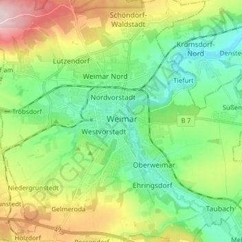
Name: Topografische Karte Weimar, Höhe, Relief.
Ort: Weimar, Thuringia, 99423, Germany (50.94028 11.28909 51.02028 11.36909)
Durchschnittliche Höhe: 282 m
Minimale Höhe: 190 m
Maximale Höhe: 468 m
Weimar is situated within the valley of Ilm river, a tributary of Saale river on the southern border of the Thuringian Basin, a fertile agricultural area between the Harz mountains 70 km (43 mi) in the north and the Thuringian Forest 50 km (31 mi) in the southwest. The municipal terrain is hilly; the height of the city centre in Ilm valley is approximately 200 m of elevation. To the north, the terrain rises to Ettersberg, the city's backyard mountain, 482 m in height. The range of hills in the south of Weimar rises up to 370 m and is part of the Ilm Saale Plate Muschelkalk formation. The eastern, central and western parts of the municipal territory are in agricultural use, whereas the Ettersberg and some southern areas are wooded.