
Topografische Karte Roodepoort
Interaktive Karte
Klicken Sie auf die Karte, um die Höhe anzuzeigen.
Über diese Karte
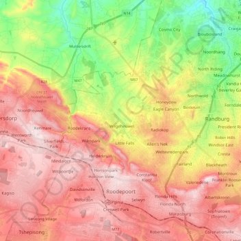
Name: Topografische Karte Roodepoort, Höhe, Relief.
Durchschnittliche Höhe: 1.593 m
Minimale Höhe: 1.343 m
Maximale Höhe: 1.803 m
Andere topografische Karten
Klicken Sie auf eine Karte, um ihre Topografie, ihre Höhe und ihr Relief anzuzeigen.
Jukskei River
South Africa > Gauteng > City of Johannesburg Metropolitan Municipality
Jukskei River, City of Johannesburg Metropolitan Municipality, Gauteng, South Africa
Durchschnittliche Höhe: 1.528 m
City of Johannesburg Metropolitan Municipality
South Africa > Gauteng > City of Johannesburg Metropolitan Municipality
City of Johannesburg Metropolitan Municipality, Gauteng, 2904, South Africa
Durchschnittliche Höhe: 1.615 m
Johannesburg
South Africa > Gauteng > City of Johannesburg Metropolitan Municipality
Johannesburg, City of Johannesburg Metropolitan Municipality, Gauteng, 2001, South Africa
Durchschnittliche Höhe: 1.615 m