
Topografische Karte Lake Arrowhead
Interaktive Karte
Klicken Sie auf die Karte, um die Höhe anzuzeigen.
Über diese Karte
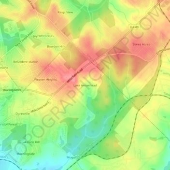
Name: Topografische Karte Lake Arrowhead, Höhe, Relief.
Durchschnittliche Höhe: 137 m
Minimale Höhe: 93 m
Maximale Höhe: 172 m
Andere topografische Karten
Klicken Sie auf eine Karte, um ihre Topografie, ihre Höhe und ihr Relief anzuzeigen.
Heritage Acres
United States > Georgia > Bibb County > Macon
Heritage Acres, Macon, Bibb County, Georgia, 31211, United States
Durchschnittliche Höhe: 119 m
Sofkee
United States > Georgia > Bibb County > Macon
Sofkee, Macon, Bibb County, Georgia, 31297, United States
Durchschnittliche Höhe: 110 m
Avondale
United States > Georgia > Bibb County > Macon
Avondale, Macon, Bibb County, Georgia, 31297, United States
Durchschnittliche Höhe: 98 m
Wood Valley
United States > Georgia > Bibb County > Macon
Wood Valley, Macon, Bibb County, Georgia, 31211, United States
Durchschnittliche Höhe: 120 m
Christophers Cove
United States > Georgia > Bibb County > Macon
Christophers Cove, Macon, Bibb County, Georgia, 31220, United States
Durchschnittliche Höhe: 130 m
Lizella
United States > Georgia > Bibb County > Macon > Lizella
Lizella, Macon, Bibb County, Georgia, 31052, United States
Durchschnittliche Höhe: 146 m
Ocmulgee Mounds National Historical Park
United States > Georgia > Bibb County > Macon
Ocmulgee Mounds National Historical Park, Short Circle, Macon, Bibb County, Georgia, 31201-1662, United States
Durchschnittliche Höhe: 96 m
Idlewood
United States > Georgia > Bibb County > Macon
Idlewood, Macon, Bibb County, Georgia, 31210, United States
Durchschnittliche Höhe: 132 m