
Topografische Karte Cullinan
Interaktive Karte
Klicken Sie auf die Karte, um die Höhe anzuzeigen.
Über diese Karte
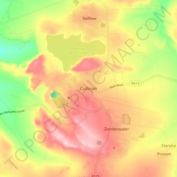
Name: Topografische Karte Cullinan, Höhe, Relief.
Durchschnittliche Höhe: 1.420 m
Minimale Höhe: 1.294 m
Maximale Höhe: 1.521 m
Cullinan is situated in the Highveld region of South Africa. The town has an elevation of 1476 m (4842.52 ft) and is located at −25.6709 [latitude in decimal degrees], 28.5236 [longitude in decimal degrees]. The closest city is Pretoria being 40 km (25 mi) away, while Johannesburg is 100 km (62 mi) away.
Andere topografische Karten
Klicken Sie auf eine Karte, um ihre Topografie, ihre Höhe und ihr Relief anzuzeigen.
Kruin Park
South Africa > Gauteng > City of Tshwane Metropolitan Municipality > Pretoria
Kruin Park, Muckleneuk, Tshwane Ward 59, Pretoria, City of Tshwane Metropolitan Municipality, Gauteng, 0027, South Africa
Durchschnittliche Höhe: 1.380 m
Centurion
South Africa > Gauteng > City of Tshwane Metropolitan Municipality
Centurion, City of Tshwane Metropolitan Municipality, Gauteng, 0014, South Africa
Durchschnittliche Höhe: 1.451 m
Pretoria
South Africa > Gauteng > City of Tshwane Metropolitan Municipality
Pretoria, City of Tshwane Metropolitan Municipality, Gauteng, 0126, South Africa
Durchschnittliche Höhe: 1.363 m
Bronkhorstspruit
South Africa > Gauteng > City of Tshwane Metropolitan Municipality
Bronkhorstspruit, City of Tshwane Metropolitan Municipality, Gauteng, South Africa
Durchschnittliche Höhe: 1.411 m
Akasia
South Africa > Gauteng > City of Tshwane Metropolitan Municipality
Akasia, City of Tshwane Metropolitan Municipality, Gauteng, 0118, South Africa
Durchschnittliche Höhe: 1.309 m