
Topografische Karte Greenwood
Interaktive Karte
Klicken Sie auf die Karte, um die Höhe anzuzeigen.
Über diese Karte
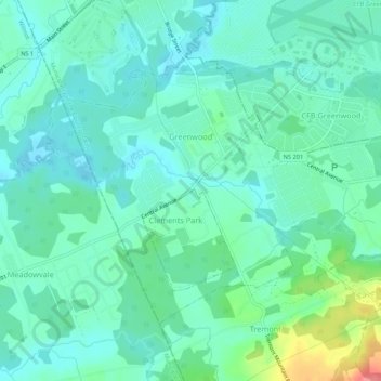
Name: Topografische Karte Greenwood, Höhe, Relief.
Durchschnittliche Höhe: 28 m
Minimale Höhe: 11 m
Maximale Höhe: 85 m
Andere topografische Karten
Klicken Sie auf eine Karte, um ihre Topografie, ihre Höhe und ihr Relief anzuzeigen.
Canning
Canada > Nova Scotia > Municipality of the County of Kings
Canning, Municipality of the County of Kings, Kings County, Nova Scotia, B0P 1H0, Canada
Durchschnittliche Höhe: 22 m
Ross Creek
Canada > Nova Scotia > Municipality of the County of Kings
Ross Creek, Municipality of the County of Kings, Kings County, Nova Scotia, B0P 1H0, Canada
Durchschnittliche Höhe: 100 m
Tremont
Canada > Nova Scotia > Municipality of the County of Kings
Tremont, Municipality of the County of Kings, Kings County, Nova Scotia, B0P 1R0, Canada
Durchschnittliche Höhe: 58 m
Forest Hill
Canada > Nova Scotia > Municipality of the County of Kings
Forest Hill, Municipality of the County of Kings, Kings County, Nova Scotia, B4P 2R1, Canada
Durchschnittliche Höhe: 184 m