
Topografische Karte Muthill
Interaktive Karte
Klicken Sie auf die Karte, um die Höhe anzuzeigen.
Über diese Karte
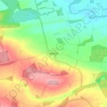
Name: Topografische Karte Muthill, Höhe, Relief.
Ort: Muthill, Perth and Kinross, Scotland, PH5 2AW, United Kingdom (56.31176 -3.85346 56.35176 -3.81346)
Durchschnittliche Höhe: 85 m
Minimale Höhe: 25 m
Maximale Höhe: 162 m
Andere topografische Karten
Klicken Sie auf eine Karte, um ihre Topografie, ihre Höhe und ihr Relief anzuzeigen.
Culteuchar
United Kingdom > Scotland > Perth and Kinross > Perth
Culteuchar, Perth, Perth and Kinross, Scotland, PH2 9HL, United Kingdom
Durchschnittliche Höhe: 194 m
Bridge of Earn
United Kingdom > Scotland > Perth and Kinross
Bridge of Earn, Perth and Kinross, Scotland, PH2 9PL, United Kingdom
Durchschnittliche Höhe: 70 m
Blairgowrie and Rattray
United Kingdom > Scotland > Perth and Kinross
Blairgowrie and Rattray, Perth and Kinross, Scotland, PH10 6AB, United Kingdom
Durchschnittliche Höhe: 121 m
Wolfhill
United Kingdom > Scotland > Perth and Kinross
Wolfhill, Perth and Kinross, Scotland, PH2 6TH, United Kingdom
Durchschnittliche Höhe: 118 m
Forgandenny
United Kingdom > Scotland > Perth and Kinross
Forgandenny, Perth and Kinross, Scotland, PH2 9EQ, United Kingdom
Durchschnittliche Höhe: 53 m