
Topografische Karte Valdivia
Interaktive Karte
Klicken Sie auf die Karte, um die Höhe anzuzeigen.
Über diese Karte
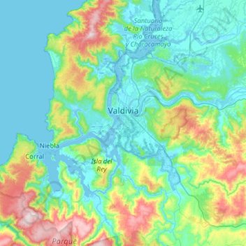
Name: Topografische Karte Valdivia, Höhe, Relief.
Ort: Valdivia, Provincia de Valdivia, Los Ríos Region, Chile (-40.03202 -73.41394 -39.63708 -72.92085)
Durchschnittliche Höhe: 143 m
Minimale Höhe: -3 m
Maximale Höhe: 705 m
Within the context of plate tectonics the city lies at a convergent margin where Nazca Plate in the Pacific is subducted beneath the South American Plate. Topographically Valdivia lies in a depression amidst the Chilean Coast Range. The basement rocks that crops out in the hills around the city are of metamorphic type. The city itself is chiefly built upon terraces made up of hardened volcanic sand. This volcanic sandstone is known as "cancagua" and deposited during the late Pleistocene epoch. As terraces took shape during the interglacial preceding the Llanquihue glaciation —the last glacial period— this interglacial is known in Chile as the Valdivia interglacial.
Andere topografische Karten
Klicken Sie auf eine Karte, um ihre Topografie, ihre Höhe und ihr Relief anzuzeigen.
Neltume
Chile > Los Ríos Region > Provincia de Valdivia
Neltume, Panguipulli, Provincia de Valdivia, Los Ríos Region, Chile
Durchschnittliche Höhe: 658 m
Villa California
Chile > Los Ríos Region > Provincia de Valdivia > Valdivia
Villa California, Valdivia, Provincia de Valdivia, Los Ríos Region, 5100861, Chile
Durchschnittliche Höhe: 27 m
Villa Endesa
Chile > Los Ríos Region > Provincia de Valdivia > Valdivia
Villa Endesa, Valdivia, Provincia de Valdivia, Los Ríos Region, 5110244, Chile
Durchschnittliche Höhe: 8 m