
Topografische Karte Cuatro Esquinas
Interaktive Karte
Klicken Sie auf die Karte, um die Höhe anzuzeigen.
Über diese Karte
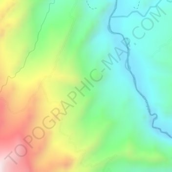
Name: Topografische Karte Cuatro Esquinas, Höhe, Relief.
Ort: Cuatro Esquinas, Miraflores, Lengupá, Boyacá, Colombia (5.16649 -73.11863 5.18649 -73.09863)
Durchschnittliche Höhe: 1.190 m
Minimale Höhe: 959 m
Maximale Höhe: 1.562 m
Andere topografische Karten
Klicken Sie auf eine Karte, um ihre Topografie, ihre Höhe und ihr Relief anzuzeigen.
Vereda Arrayán
Colombia > Boyacá > Miraflores > Miraflores
Vereda Arrayán, Miraflores, Lengupá, Boyacá, RAP (Especial) Central, Colombia
Durchschnittliche Höhe: 1.518 m
El Morro Arriba
Colombia > Boyacá > Miraflores
El Morro Arriba, Miraflores, Lengupá, Boyacá, RAP (Especial) Central, Colombia
Durchschnittliche Höhe: 1.877 m