
Topografische Karte Kangazha
Interaktive Karte
Klicken Sie auf die Karte, um die Höhe anzuzeigen.
Über diese Karte
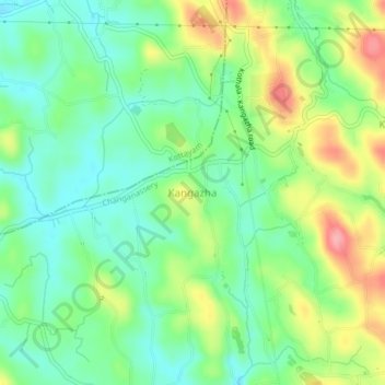
Name: Topografische Karte Kangazha, Höhe, Relief.
Ort: Kangazha, Changanassery, Kottayam, Kerala, 686521, India (9.51394 76.65130 9.55394 76.69130)
Durchschnittliche Höhe: 73 m
Minimale Höhe: 31 m
Maximale Höhe: 147 m
Andere topografische Karten
Klicken Sie auf eine Karte, um ihre Topografie, ihre Höhe und ihr Relief anzuzeigen.
Vazhoor
India > Kerala > Changanassery
Vazhoor, Changanassery, Kottayam District, Kerala, 686504, India
Durchschnittliche Höhe: 91 m
Kurichy
India > Kerala > Changanassery > Putuppalli
Kurichy, Putuppalli, Changanassery, Kottayam, Kerala, India
Durchschnittliche Höhe: 11 m
Perumpanachy
India > Kerala > Changanassery
Perumpanachy, Changanassery, Kottayam, Kerala, 686536, India
Durchschnittliche Höhe: 24 m
Sri Subramanya swami Kshethra Kulam, Perunna
India > Kerala > Changanassery > Changanassery
Sri Subramanya swami Kshethra Kulam, Perunna, Perunna, Changanassery, Kottayam, Kerala, India
Durchschnittliche Höhe: 6 m
Karukachal
India > Kerala > Changanassery > Karukachal
Karukachal, Changanassery, Kottayam, Kerala, 686540, India
Durchschnittliche Höhe: 49 m
Thrikkodithanam
India > Kerala > Changanassery > Valiyakulam
Thrikkodithanam, Valiyakulam, Changanassery, Kottayam, Kerala, 686105, India
Durchschnittliche Höhe: 22 m
Cheeranchira
India > Kerala > Changanassery > Kurishummoodu
Cheeranchira, Kurishummoodu, Changanassery, Kottayam, Kerala, India
Durchschnittliche Höhe: 18 m
Mammodu
India > Kerala > Changanassery > Mammodu
Mammodu, Changanassery, Kottayam, Kerala, 686536, India
Durchschnittliche Höhe: 34 m
Koothrapally Pond,koothrapally
India > Kerala > Changanassery > Karukachal
Koothrapally Pond,koothrapally, Karukachal, Changanassery, Kottayam, Kerala, India
Durchschnittliche Höhe: 54 m