
Topografische Karte Charleston County
Interaktive Karte
Klicken Sie auf die Karte, um die Höhe anzuzeigen.
Über diese Karte
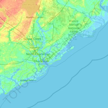
Name: Topografische Karte Charleston County, Höhe, Relief.
Ort: Charleston County, South Carolina, USA (32.49280 -80.45191 33.21502 -79.25611)
Durchschnittliche Höhe: 5 m
Minimale Höhe: -4 m
Maximale Höhe: 40 m
Andere topografische Karten
Klicken Sie auf eine Karte, um ihre Topografie, ihre Höhe und ihr Relief anzuzeigen.
Fulton Acres
USA > South Carolina > Fulton Acres
Fulton Acres, Spartanburg County, South Carolina, USA
Durchschnittliche Höhe: 284 m
Fort Mill
USA > South Carolina > Fort Mill
Fort Mill, York County, South Carolina, 29715, USA
Durchschnittliche Höhe: 182 m
Cape Romain National Wildlife Refuge
USA > South Carolina > Awendaw
Cape Romain National Wildlife Refuge, Awendaw, Charleston County, South Carolina, USA
Durchschnittliche Höhe: 3 m
Pine Creek
USA > South Carolina > Pine Creek
Pine Creek, Kershaw County, South Carolina, 29020, USA
Durchschnittliche Höhe: 73 m
Tenmile
USA > South Carolina > Tenmile
Tenmile, Charleston County, South Carolina, 29416, USA
Durchschnittliche Höhe: 9 m
Grenadier
USA > South Carolina > Grenadier
Grenadier, Lexington County, South Carolina, 29210, USA
Durchschnittliche Höhe: 74 m