
Topografische Karte Annan
Interaktive Karte
Klicken Sie auf die Karte, um die Höhe anzuzeigen.
Über diese Karte
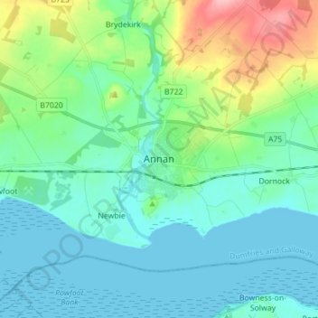
Name: Topografische Karte Annan, Höhe, Relief.
Durchschnittliche Höhe: 26 m
Minimale Höhe: 0 m
Maximale Höhe: 117 m
Andere topografische Karten
Klicken Sie auf eine Karte, um ihre Topografie, ihre Höhe und ihr Relief anzuzeigen.
Langholm
United Kingdom > Scotland > Dumfries and Galloway
Langholm, Dumfries and Galloway, Scotland, DG13 0JQ, United Kingdom
Durchschnittliche Höhe: 185 m
Manitou
United Kingdom > Scotland > Dumfries and Galloway
Manitou, Dumfries and Galloway, Scotland, United Kingdom
Durchschnittliche Höhe: 167 m
Gatehouse of Fleet
United Kingdom > Scotland > Dumfries and Galloway
Gatehouse of Fleet, Dumfries and Galloway, Scotland, DG7 2HR, United Kingdom
Durchschnittliche Höhe: 64 m