
Topografische Karte Saint John's Park
Interaktive Karte
Klicken Sie auf die Karte, um die Höhe anzuzeigen.
Über diese Karte
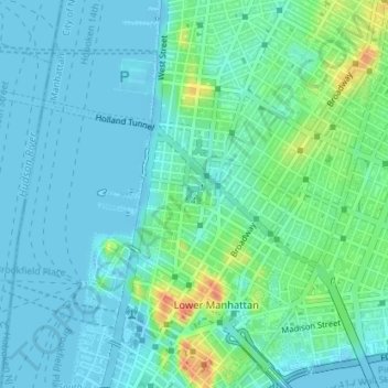
Name: Topografische Karte Saint John's Park, Höhe, Relief.
Durchschnittliche Höhe: 11 m
Minimale Höhe: -7 m
Maximale Höhe: 47 m
It took over 20 years for all the lots to be sold and developed, partly because of the swampy topography, but also because the church was only offering 99-year leases, not outright ownership of the lots, with covenants which limited the heights of residences and the materials they were built with. During this period, St. John's Chapel had very few parishioners. The 64 lots were eventually sold when Trinity changed its policy and decided to sell lots outright, deeding the exclusive use of the square to the lot owners. The sales had the attached covenant that if the owners failed to properly keep up the square it would be given to the city for public use.
Andere topografische Karten
Klicken Sie auf eine Karte, um ihre Topografie, ihre Höhe und ihr Relief anzuzeigen.
The Bronx
United States > New York > New York
The Bronx, New York, United States
Durchschnittliche Höhe: 23 m
Hallet’s Cove
United States > New York > New York
Hallet’s Cove, Astoria, Queens, New York, United States
Durchschnittliche Höhe: 9 m
Queens
United States > New York > New York
Queens, New York, United States
Durchschnittliche Höhe: 12 m
Brooklyn
United States > New York > New York
Brooklyn, Kings County, New York, United States
Durchschnittliche Höhe: 9 m
Richmond County
United States > New York > New York
Richmond County, New York, United States
Durchschnittliche Höhe: 9 m
Queens County
United States > New York > New York
Queens County, New York, United States
Durchschnittliche Höhe: 11 m
Kings County
United States > New York > New York
Kings County, New York, United States
Durchschnittliche Höhe: 9 m
Bronx County
United States > New York > New York
Bronx County, The Bronx, New York, United States
Durchschnittliche Höhe: 21 m