
Topografische Karte Krasnoyarsk
Interaktive Karte
Klicken Sie auf die Karte, um die Höhe anzuzeigen.
Über diese Karte
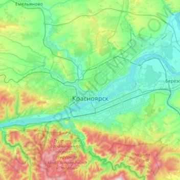
Name: Topografische Karte Krasnoyarsk, Höhe, Relief.
Durchschnittliche Höhe: 285 m
Minimale Höhe: 118 m
Maximale Höhe: 792 m
The river Yenisei flows from west to east through the city. Due to the Krasnoyarsk hydroelectric dam 32 km (20 mi) upstream, the Yenisei never freezes in winter and never exceeds +14 °C (57 °F) in summer through the city. Near the city center, its elevation is 136 m (446 ft) above sea level. There are several islands in the river, the largest of which are Tatyshev and Otdyha Isles, used mainly for recreation.