
Topografische Karte Ironwood
Interaktive Karte
Klicken Sie auf die Karte, um die Höhe anzuzeigen.
Über diese Karte
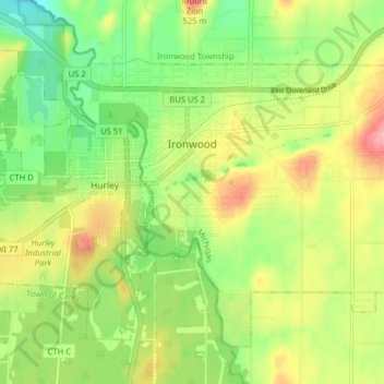
Name: Topografische Karte Ironwood, Höhe, Relief.
Ort: Ironwood, Gogebic County, Michigan, United States (46.42665 -90.19361 46.47068 -90.11415)
Durchschnittliche Höhe: 458 m
Minimale Höhe: 406 m
Maximale Höhe: 524 m
In the early 1960s, the U.S. Air Force established a Strategic Air Command (SAC) Radar Bomb Scoring site atop Norrie hill to track and score high altitude and treetop level simulated bomb runs by B-52s and B-47s on targets in the Ironwood area. A monument is erected south of Hurley, Wisconsin to remember those crew members killed in two B-47 low level runs. The site was moved to Charlevoix, Michigan in the mid-1960s.
Andere topografische Karten
Klicken Sie auf eine Karte, um ihre Topografie, ihre Höhe und ihr Relief anzuzeigen.
Wakefield
United States > Michigan > Gogebic County
Wakefield, Gogebic County, Michigan, 49968, United States
Durchschnittliche Höhe: 460 m
Marenisco
United States > Michigan > Gogebic County
Marenisco, Marenisco Township, Gogebic County, Michigan, 49947, United States
Durchschnittliche Höhe: 477 m
Ramsay
United States > Michigan > Gogebic County
Ramsay, Bessemer Township, Gogebic County, Michigan, 49959, United States
Durchschnittliche Höhe: 467 m
Puritan
United States > Michigan > Gogebic County
Puritan, Bessemer Township, Gogebic County, Michigan, 49911, United States
Durchschnittliche Höhe: 463 m
Ironwood Township
United States > Michigan > Gogebic County
Ironwood Township, Gogebic County, Michigan, United States
Durchschnittliche Höhe: 311 m
Copper Peak
United States > Michigan > Gogebic County
Copper Peak, Ironwood Township, Gogebic County, Michigan, United States
Durchschnittliche Höhe: 356 m
Fishhawk Lake
United States > Michigan > Gogebic County
Fishhawk Lake, Watersmeet Township, Gogebic County, Michigan, United States
Durchschnittliche Höhe: 517 m
Watersmeet
United States > Michigan > Gogebic County
Watersmeet, Watersmeet Township, Gogebic County, Michigan, 49969, United States
Durchschnittliche Höhe: 499 m
Bessemer
United States > Michigan > Gogebic County
Bessemer, Gogebic County, Michigan, 49911, United States
Durchschnittliche Höhe: 458 m