
Topografische Karte Moon
Interaktive Karte
Klicken Sie auf die Karte, um die Höhe anzuzeigen.
Über diese Karte
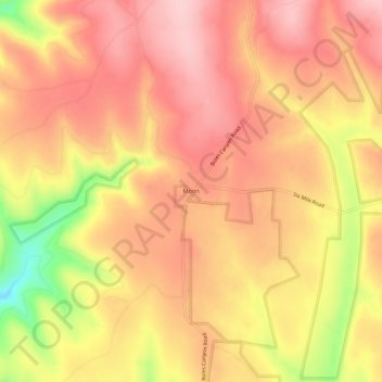
Name: Topografische Karte Moon, Höhe, Relief.
Ort: Moon, Pennington County, South Dakota, United States (43.92637 -104.02826 43.96637 -103.98826)
Durchschnittliche Höhe: 1.938 m
Minimale Höhe: 1.814 m
Maximale Höhe: 1.999 m
Andere topografische Karten
Klicken Sie auf eine Karte, um ihre Topografie, ihre Höhe und ihr Relief anzuzeigen.
Black Hills
United States > South Dakota > Pennington County
Black Hills, Pennington County, South Dakota, United States
Durchschnittliche Höhe: 1.894 m
Sage Creek Basin Overlook
United States > South Dakota > Pennington County
Sage Creek Basin Overlook, Rim Road, Pennington County, South Dakota, United States
Durchschnittliche Höhe: 869 m
Sage Creek
United States > South Dakota > Pennington County
Sage Creek, Pennington County, South Dakota, United States
Durchschnittliche Höhe: 865 m
Mount Rushmore
United States > South Dakota > Pennington County
Mount Rushmore, Pennington County, South Dakota, 57751, United States
Durchschnittliche Höhe: 1.562 m
Rapid Creek
United States > South Dakota > Pennington County
Rapid Creek, Pennington County, South Dakota, United States
Durchschnittliche Höhe: 1.689 m
Rapid City
United States > South Dakota > Pennington County
Rapid City, Pennington County, South Dakota, United States
Durchschnittliche Höhe: 1.068 m
Mount Rushmore National Memorial
United States > South Dakota > Pennington County
Mount Rushmore National Memorial, Pennington County, South Dakota, United States
Durchschnittliche Höhe: 1.528 m
Rapid Valley
United States > South Dakota > Pennington County > Rapid Valley
Rapid Valley, Pennington County, South Dakota, 57703-6649, United States
Durchschnittliche Höhe: 977 m