
Topografische Karte Alegranza Island
Interaktive Karte
Klicken Sie auf die Karte, um die Höhe anzuzeigen.
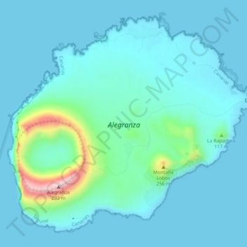
Alegranza Island
The area is 10.2 km². The island features a volcano with a crater of about 1.1 km in diameter and an altitude of 289 m. The second highest is Montaña de Lobos at 256 m and following La Rapagura. The northern portion is mainly flat.
Über diese Karte
Name: Topografische Karte Alegranza Island, Höhe, Relief.
Ort: Alegranza Island, Teguise, Las Palmas, Canary Islands, Spain (29.38263 -13.53188 29.41606 -13.48803)
Durchschnittliche Höhe: 39 m
Minimale Höhe: 0 m
Maximale Höhe: 289 m