
Topografische Karte Avon
Interaktive Karte
Klicken Sie auf die Karte, um die Höhe anzuzeigen.
Über diese Karte
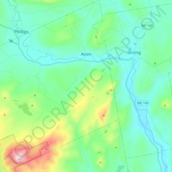
Name: Topografische Karte Avon, Höhe, Relief.
Ort: Avon, Franklin County, Maine, United States (44.71798 -70.39647 44.84647 -70.23686)
Durchschnittliche Höhe: 293 m
Minimale Höhe: 108 m
Maximale Höhe: 958 m
According to the United States Census Bureau, the town has a total area of 41.65 square miles (107.87 km2), of which 41.39 square miles (107.20 km2) is land and 0.26 square miles (0.67 km2) is water. Avon is drained by the Sandy River, a tributary of the Kennebec River. Mount Blue, elevation 3,192 feet (973 meters) above sea level (and part of Mount Blue State Park), is located in the southwestern corner of Avon.
Andere topografische Karten
Klicken Sie auf eine Karte, um ihre Topografie, ihre Höhe und ihr Relief anzuzeigen.
Dallas Plantation
United States > Maine > Franklin County
Dallas Plantation, Franklin County, Maine, United States
Durchschnittliche Höhe: 599 m
Rangeley Plantation
United States > Maine > Franklin County
Rangeley Plantation, Franklin County, Maine, United States
Durchschnittliche Höhe: 577 m
East Dixfield
United States > Maine > Franklin County > Wilton
East Dixfield, Wilton, Franklin County, Maine, 04294, United States
Durchschnittliche Höhe: 227 m
New Sharon
United States > Maine > Franklin County
New Sharon, Franklin County, Maine, 04955, United States
Durchschnittliche Höhe: 153 m
Farmington Falls
United States > Maine > Franklin County > Farmington
Farmington Falls, Farmington, Franklin County, Maine, 04940, United States
Durchschnittliche Höhe: 114 m
Oquossoc
United States > Maine > Franklin County > Rangeley
Oquossoc, Rangeley, Franklin County, Maine, United States
Durchschnittliche Höhe: 488 m
Dryden
United States > Maine > Franklin County > Wilton
Dryden, Wilton, Franklin County, Maine, 04294, United States
Durchschnittliche Höhe: 165 m
East Wilton
United States > Maine > Franklin County > Wilton
East Wilton, Wilton, Franklin County, Maine, 04294, United States
Durchschnittliche Höhe: 166 m
Coplin Plantation
United States > Maine > Franklin County
Coplin Plantation, Franklin County, Maine, United States
Durchschnittliche Höhe: 495 m
Chesterville
United States > Maine > Franklin County
Chesterville, Franklin County, Maine, United States
Durchschnittliche Höhe: 156 m
Carthage
United States > Maine > Franklin County
Carthage, Franklin County, Maine, 04224, United States
Durchschnittliche Höhe: 303 m
Eustis
United States > Maine > Franklin County
Eustis, Franklin County, Maine, United States
Durchschnittliche Höhe: 413 m
Jay
United States > Maine > Franklin County
Jay, Franklin County, Maine, 04239, United States
Durchschnittliche Höhe: 179 m
Strong
United States > Maine > Franklin County
Strong, Franklin County, Maine, 04983, United States
Durchschnittliche Höhe: 260 m
Mount Blue
United States > Maine > Franklin County > Avon
Mount Blue, Avon, Franklin County, Maine, 04262, United States
Durchschnittliche Höhe: 634 m
Weld
United States > Maine > Franklin County
Weld, Franklin County, Maine, 04285, United States
Durchschnittliche Höhe: 408 m
Industry
United States > Maine > Franklin County
Industry, Franklin County, Maine, United States
Durchschnittliche Höhe: 235 m
Kingfield
United States > Maine > Franklin County
Kingfield, Franklin County, Maine, United States
Durchschnittliche Höhe: 291 m
Phillips
United States > Maine > Franklin County
Phillips, Franklin County, Maine, 04966, United States
Durchschnittliche Höhe: 322 m
Farmington
United States > Maine > Franklin County
Farmington, Franklin County, Maine, United States
Durchschnittliche Höhe: 192 m
Stratton
United States > Maine > Franklin County > Eustis > Stratton
Stratton, Eustis, Franklin County, Maine, 04982, United States
Durchschnittliche Höhe: 374 m
Wilton
United States > Maine > Franklin County
Wilton, Franklin County, Maine, 04294, United States
Durchschnittliche Höhe: 231 m
Madrid Township
United States > Maine > Franklin County
Madrid Township, Franklin County, Maine, United States
Durchschnittliche Höhe: 522 m
Temple
United States > Maine > Franklin County
Temple, Franklin County, Maine, 04984, United States
Durchschnittliche Höhe: 266 m
Carrabassett Valley
United States > Maine > Franklin County
Carrabassett Valley, Franklin County, Maine, 04947, United States
Durchschnittliche Höhe: 495 m
Gordon Hill
United States > Maine > Franklin County > Chesterville
Gordon Hill, Chesterville, Franklin County, Maine, United States
Durchschnittliche Höhe: 151 m
New Vineyard
United States > Maine > Franklin County
New Vineyard, Franklin County, Maine, 04956, United States
Durchschnittliche Höhe: 251 m
Webb Lake
United States > Maine > Franklin County > Weld
Webb Lake, Weld, Franklin County, Maine, 04285, United States
Durchschnittliche Höhe: 247 m
Rangeley
United States > Maine > Franklin County
Rangeley, Franklin County, Maine, United States
Durchschnittliche Höhe: 548 m
Coburn Gore
United States > Maine > Franklin County
Coburn Gore, Franklin County, Maine, United States
Durchschnittliche Höhe: 467 m