
Topografische Karte Fairhaven
Interaktive Karte
Klicken Sie auf die Karte, um die Höhe anzuzeigen.
Über diese Karte
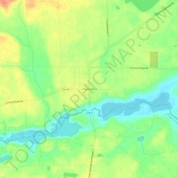
Name: Topografische Karte Fairhaven, Höhe, Relief.
Durchschnittliche Höhe: 325 m
Minimale Höhe: 302 m
Maximale Höhe: 351 m
Andere topografische Karten
Klicken Sie auf eine Karte, um ihre Topografie, ihre Höhe und ihr Relief anzuzeigen.
Sartell
United States > Minnesota > Stearns County
Sartell, Stearns County, Minnesota, 56377, United States
Durchschnittliche Höhe: 323 m
Saint Augusta
United States > Minnesota > Stearns County > St. Augusta
Saint Augusta, St. Augusta, Stearns County, Minnesota, United States
Durchschnittliche Höhe: 312 m
St. Cloud
United States > Minnesota > Stearns County
St. Cloud, Stearns County, Minnesota, United States
Durchschnittliche Höhe: 319 m
Saint Wendel
United States > Minnesota > Stearns County
Saint Wendel, Stearns County, Minnesota, United States
Durchschnittliche Höhe: 361 m
Big Watab Lake
United States > Minnesota > Stearns County
Big Watab Lake, Stearns County, Minnesota, United States
Durchschnittliche Höhe: 381 m
Avon
United States > Minnesota > Stearns County
Avon, Stearns County, Minnesota, 56310, United States
Durchschnittliche Höhe: 351 m
Pleasant Lake
United States > Minnesota > Stearns County > Rockville
Pleasant Lake, Rockville, Stearns County, Minnesota, United States
Durchschnittliche Höhe: 337 m
Sartell
United States > Minnesota > Stearns County > Sartell > Sartell
Sartell, Stearns County, Minnesota, 5377, United States
Durchschnittliche Höhe: 323 m
Melrose
United States > Minnesota > Stearns County > Melrose
Melrose, Stearns County, Minnesota, United States
Durchschnittliche Höhe: 368 m
Cold Spring
United States > Minnesota > Stearns County
Cold Spring, Stearns County, Minnesota, 56320, United States
Durchschnittliche Höhe: 349 m
Waite Park
United States > Minnesota > Stearns County
Waite Park, Stearns County, Minnesota, United States
Durchschnittliche Höhe: 334 m