
Topografische Karte Bonanza
Interaktive Karte
Klicken Sie auf die Karte, um die Höhe anzuzeigen.
Über diese Karte
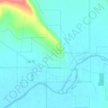
Name: Topografische Karte Bonanza, Höhe, Relief.
Ort: Bonanza, Klamath County, Oregon, United States (42.19495 -121.41855 42.20937 -121.39368)
Durchschnittliche Höhe: 1.263 m
Minimale Höhe: 1.251 m
Maximale Höhe: 1.333 m
Bonanza is at an elevation of 4,127 feet (1,258 m) in southern Klamath County near the Oregon–California border. The town is at the east end of Oregon Route 70, a spur off Oregon Route 140. By highway, Bonanza is about 21 miles (34 km) from Klamath Falls and 300 miles (483 km) from Portland.
Andere topografische Karten
Klicken Sie auf eine Karte, um ihre Topografie, ihre Höhe und ihr Relief anzuzeigen.
Klamath Falls
United States > Oregon > Klamath County
Klamath Falls, Klamath County, Oregon, 97601, United States
Durchschnittliche Höhe: 1.312 m
Dairy
United States > Oregon > Klamath County
Dairy, Klamath County, Oregon, 97625, United States
Durchschnittliche Höhe: 1.300 m
Crater Lake National Park
United States > Oregon > Klamath County
Crater Lake National Park, Klamath County, Oregon, 97604, United States
Durchschnittliche Höhe: 1.726 m
Rock Point
United States > Oregon > Klamath County
Rock Point, Klamath County, Oregon, 97731, United States
Durchschnittliche Höhe: 1.415 m
Altamont
United States > Oregon > Klamath County
Altamont, Klamath County, Oregon, 97603, United States
Durchschnittliche Höhe: 1.310 m
Lake of the Woods
United States > Oregon > Klamath County
Lake of the Woods, Klamath County, Oregon, United States
Durchschnittliche Höhe: 1.588 m
Chemult
United States > Oregon > Klamath County
Chemult, Klamath County, Oregon, United States
Durchschnittliche Höhe: 1.480 m
Crescent
United States > Oregon > Klamath County
Crescent, Klamath County, Oregon, United States
Durchschnittliche Höhe: 1.389 m
Sprague River
United States > Oregon > Klamath County
Sprague River, Klamath County, Oregon, 97639, United States
Durchschnittliche Höhe: 1.472 m
Malin
United States > Oregon > Klamath County
Malin, Klamath County, Oregon, United States
Durchschnittliche Höhe: 1.241 m
Altamont
United States > Oregon > Klamath County > Altamont
Altamont, Klamath County, Oregon, 97603, United States
Durchschnittliche Höhe: 1.285 m
Merrill
United States > Oregon > Klamath County
Merrill, Klamath County, Oregon, United States
Durchschnittliche Höhe: 1.241 m
Mount Scott
United States > Oregon > Klamath County
Mount Scott, Klamath County, Oregon, United States
Durchschnittliche Höhe: 2.295 m
Fort Klamath
United States > Oregon > Klamath County
Fort Klamath, Klamath County, Oregon, United States
Durchschnittliche Höhe: 1.273 m
Chiloquin
United States > Oregon > Klamath County
Chiloquin, Klamath County, Oregon, United States
Durchschnittliche Höhe: 1.302 m
Beatty
United States > Oregon > Klamath County
Beatty, Klamath County, Oregon, 97602, United States
Durchschnittliche Höhe: 1.330 m
Odell Lake
United States > Oregon > Klamath County > Odell Lake
Odell Lake, Klamath County, Oregon, United States
Durchschnittliche Höhe: 1.492 m
Crater Lake
United States > Oregon > Klamath County
Crater Lake, Klamath County, Oregon, United States
Durchschnittliche Höhe: 1.971 m
Keno
United States > Oregon > Klamath County
Keno, Klamath County, Oregon, 97627, United States
Durchschnittliche Höhe: 1.287 m
Mount Mazama
United States > Oregon > Klamath County
Mount Mazama, Klamath County, Oregon, United States
Durchschnittliche Höhe: 1.880 m