
Spenden
Rüste dich für dein nächstes Abenteuer:
Als Amazon-Partner verdient diese Website an qualifizierten Käufen, ohne zusätzliche Kosten für Sie.
Topografische Karte Pusey State Game Refuge
Klicken Sie auf die Karte, um die Höhe anzuzeigen.
Spenden
Rüste dich für dein nächstes Abenteuer:
Als Amazon-Partner verdient diese Website an qualifizierten Käufen, ohne zusätzliche Kosten für Sie.
Über diese Karte
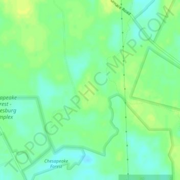
Name: Topografische Karte Pusey State Game Refuge, Höhe, Relief.
Durchschnittliche Höhe: 12 m
Minimale Höhe: 3 m
Maximale Höhe: 19 m
Spenden
Rüste dich für dein nächstes Abenteuer:
Als Amazon-Partner verdient diese Website an qualifizierten Käufen, ohne zusätzliche Kosten für Sie.
Andere topografische Karten
Klicken Sie auf eine Karte, um ihre Topografie, ihre Höhe und ihr Relief anzuzeigen.
Assateague State Park
United States > Maryland > Worcester County > Berlin > Golf Club Shores
Durchschnittliche Höhe: 1 m
Assateague Island National Seashore
United States > Maryland > Worcester County > West Ocean City
Durchschnittliche Höhe: 2 m
Snow Hill
United States > Maryland > Worcester County
Snow Hill was founded in 1686 in Somerset County by English settlers, who may have named it after a street and neighborhood of the City of London called "Snow Hill", despite the location's elevation of just 16 feet (4.9 m) above sea level and the infrequency of snowfall. The town received its first charter on…
Durchschnittliche Höhe: 7 m
Spenden
Rüste dich für dein nächstes Abenteuer:
Als Amazon-Partner verdient diese Website an qualifizierten Käufen, ohne zusätzliche Kosten für Sie.
Isle of Wight Bay
United States > Maryland > Worcester County > Ocean City
Durchschnittliche Höhe: 1 m